News
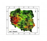
Drought monitoring in 2022 (June 18 - 25)

The system for monitoring crop growth conditions has been elaborated at the Remote Sensing Centre, Institute of Geodesy and Cartography. It determines crop conditions with the use of the index based on Terra MODIS satellite images with 1 km2 spatial resolution. The index, called Drought Identification Satellite System – DISS is a function of Temperature Condition Index – TCI and meteorological index characterizing climatic conditions on the territory of Poland (Hydrothermal Coefficient – HTC).
The InCoNaDa project was presented in the IX National Conference "GIS in Science" 2022

The InCoNaDa project was presented in the IX National Conference "GIS in Science" 2022
on 23-24 June in Toruń.
Researchers from the Centre of Applied Geomatics at IGIK on the InCoNaDa project meeting in Norway
The representatives of the Polish institutions: the Centre of Applied Geomatics at IGIK, the Lodz University of Technology and the Institute of Environmental Protection -PIB (National Centre for Balancing and Emission Management - KOBIZE) met with scientists from the Norwegian Institute of Bioeconomy Research (NIBIO). The hybrid meeting took place 14-16 June 2022 at the NIBIO's headquarters in As, Norway.
Offer of a post-doc position at the IGIK Center for Applied Geomatics
The Centre of Applied Geomatics at the Institute of Geodesy and Cartography, Warsaw, Poland, offers a post-doc position in the project funded by the National Science Centre (NCN) OPUS21 entitled: “Assessment of the impact of weather conditions on forest health status and forest disturbances at regional and national scale based on the integration of ground and space-based remote sensing datasets”.
IGIK scientists at the ESA Living Planet Symposium
Scientists from the Remote Sensing Center and the Center of Applied Geomatics present the results of research projects at the Living Planet Symposium organized by the European Space Agency, on May 23-27, 2022 in Bonn.
